ORLANDO, Fla. — Channel 9 meteorologists are watching a large active tropical area in the Caribbean.
▶ WATCH CHANNEL 9 EYEWITNESS NEWS
11 p.m. update:
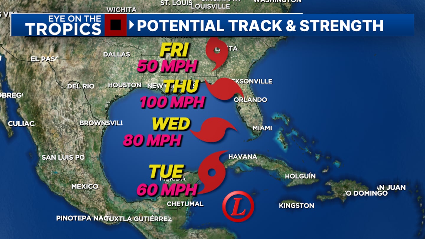
Local impacts from soon-to-be hurricane Helene will start Wednesday and peak Thursday with a major hurricane forecast to make landfall Thursday in or near the “big bend.” Tropical storm conditions are likely for us, with gusts to near hurricane strength west. 3-6″ of rain with higher amount NW nearer landfall.
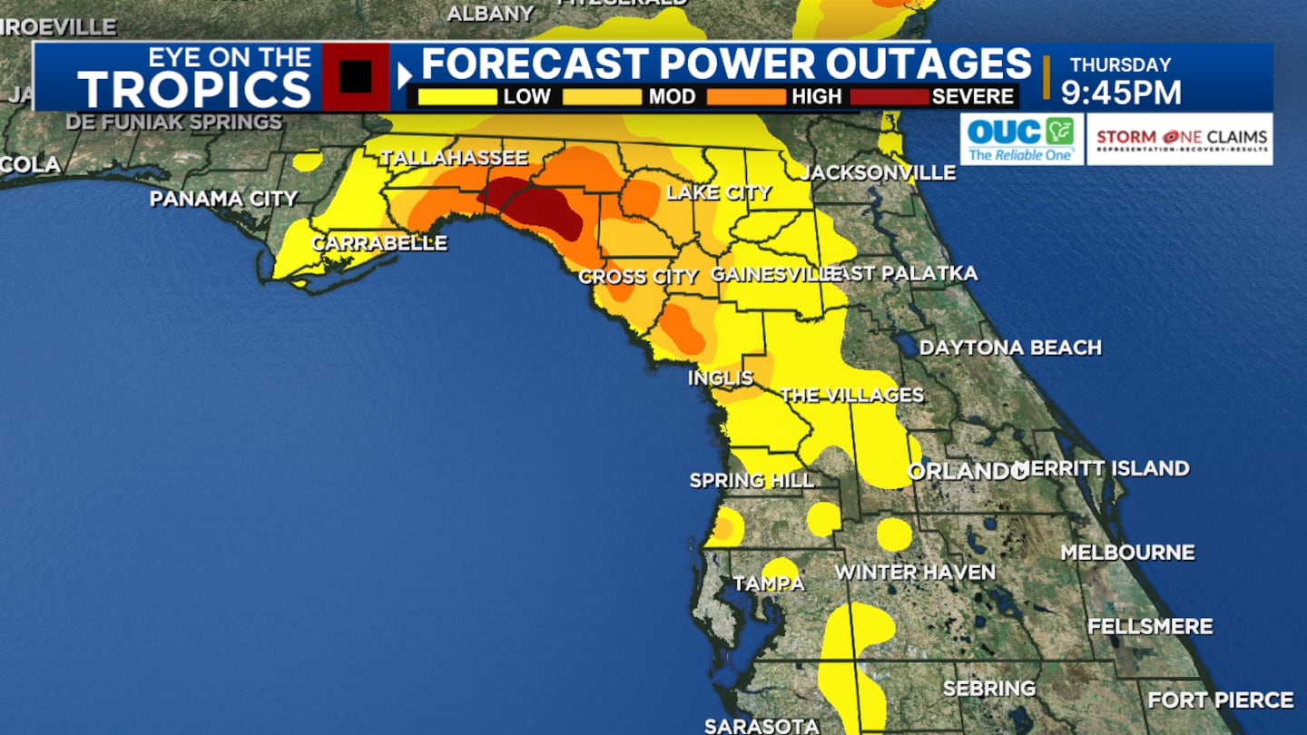
Scattered power outages will start Thursday afternoon closer to the Tampa gulf coast, then move northward, and near Tallahassee Thursday night. Make sure you prepare for power outages, especially in/along I-75.
5 p.m. update:
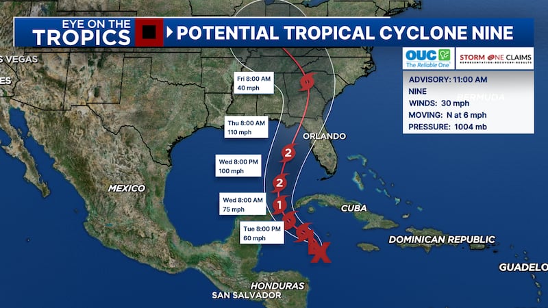
Chief Meteorologist Tom Terry said rapid intensification is looking more likely as Potential Tropical Cyclone Nine grows into major hurricane Helene by Thursday.
Landfall near Florida’s Big Bend on Thursday afternoon.
Widespread hurricane and tropical storm advisories are coming for Florida.
1:30 p.m. update:
Governor Ron DeSantis issued an executive order for Tropical Cyclone Nine, declaring a state of emergency in 41 Florida counties ahead of the storm.
Read: State of emergency issued for 41 Florida counties ahead of possible storm
11 a.m. update:
The National Hurricane Center has upgraded the storm system in the Caribbean to Potential Tropical Cyclone Nine.
PTC9 is forecast to strengthen into a hurricane in the Gulf of Mexico over the next few days.
Read: Hurricane Charley devastated much of Central Florida 20 years ago
Tropical Storm Warnings and Hurricane Watches have been issued For parts of Mexico and Cuba.
The track of the storm is still heading towards the Big Bend area of Florida by Thursday.
Areas along the Gulf Coast, especially Coastal Alabama, Florida’s Panhandle, and Florida’s West Coast, should continue to monitor this storm system closely.
See the latest forecast on Eyewitness News at Noon.
0 of 26


Original report:
The low-pressure area has a 90% of developing into a named storm over the next two days.
The system will be called Helene after it strengthens and organizes.
Read: Sunny and dry in Central Florida before tropical system brings big chances this week
The tropical system will eventually move into the Gulf of Mexico and is forecast to become a hurricane.
As of now, it looks like there will be a landfall around the Big Bend of Florida later in the day on Thursday.
Read: 9 ways to celebrate fall in Central Florida
This would be a similar scenario to Hurricane Debby, where the main action is west of us, but we could get some feeder bands.
Of course, there will be changes—it hasn’t even developed yet, so the forecast track may shift east or west, depending on where the center forms.
Read: Action 9: How to prepare before the storm
The potential for periods of heavy rain and windy conditions is increasing from Wednesday night through early Friday.
Follow our Severe Weather team on X for live updates:

©2024 Cox Media Group


